 |
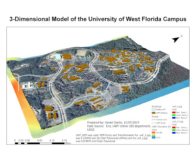
| Figure 1: 3-D Model of the UWF Main Campus |
Thursday, November 7, 2019
Georeferencing and 3D Model
This lab works was with georeferencing and 3D model of the UWF campus imagery. The lime green and brown colors represent the UWF buildings, whereas the Mapped Building 072. Pale white is the general road of the UWF campus, while blue is the Campus Lane road we mapped. To create the 3D image of UWF campus, UWF_Lidar.lasd was used. The red dot represents the Eagle nest near UWF campus.
Subscribe to:
Post Comments (Atom)
The Final Project, GIS 5043 Lab
Below is the final result of the semester work on ArcGIS. This link contains a storymap of a proposed idea of study on a transmission line ...
-
This lab works was with georeferencing and 3D model of the UWF campus imagery. The lime green and brown colors represent the UWF buildings, ...
-
Below is the final result of the semester work on ArcGIS. This link contains a storymap of a proposed idea of study on a transmission line ...
-
This lab worked with and modifying vector data. Specifically, we worked with creating buffer of water and roads, then using the Union fun...


No comments:
Post a Comment